All posts by Gabor Mikes

Oscarsborg Akustiske

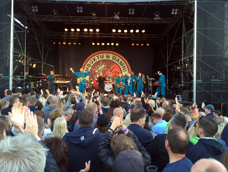
Timbuktu & Damn!
Timbuktu & Damn! at Oscarsborg Akustiske 2015

This entry made it onto this sailing logbook because Oscarsborg, the venue of Oscarsborg Akustiske, is also a sailing destination.

We set out after lunch on Friday to try to squeeze into the guest harbor at Oscarsborg – no chance! Instead we moored in an almost empty guest-harbor in Drøbak, and had to ferry over for the concert. To secure a spot in Oscarsborg guest harbor, the locals sail over, days beforehand and leave their boats there.

Chart thumb

Oscarsborg

Latitude: 59° 40.641 N
Longitude: 10° 36.293 E

Click chart to view larger scope, or here for an even larger scope in a separate window.


Chart data ©Kartverket.

Party-boat bay

Party-boat bay
There is six party-boats in this picture and I think there is a seventh hiding somewhere

Judging from the start of this season, there is not going to be any less party-boats congregating in our second favorite bay this year.

Chart thumb

Ostøya

Latitude: 59° 52.581 N
Longitude: 10° 34.73 E

Click chart to view larger scope, or here for an even larger scope in a separate window.


Chart data ©Kartverket.

Dolly visits

I am pretty sure this is the duck we fed pita last weekend. So I assume she boarded Ventulus for more pita, and not because she share our taste in music.

Chart thumb

Lille Ostsundet

Latitude: 59° 52.574 N
Longitude: 10° 35.016 E

Click chart to view larger scope, or here for an even larger scope in a separate window.


Chart data ©Kartverket.

Windless evening sailing

Absolutely no wind, but a nice sunset over Gressholmen

No point in hoisting sails. Instead we resolved to feed the ducks and enjoyed the the evening ambiance. We were pretty safe too, since almost all 50 meters of chain rumbled out, in a moment of confused communication, in 12 meters of dead calm water.

A feisty pair of duck
Chart thumb

Gressholmen

Latitude: 59° 52.978 N
Longitude: 10° 43.628 E

Click chart to view larger scope, or here for an even larger scope in a separate window.


Chart data ©Kartverket.

Open letter to a powerboat captain

On Friday September 12th about 5 or 6 in the afternoon we made our way through the narrow south-eastern entrance of Lille Ostsundet. Approaching from the opposite side was a powerboat, but as we were considerably closer, I estimated that we could get through without hindering the powerboat significantly. The powerboat however, kept up its speed and heading until we came much too close, just as we escaped the narrow channel. Behind us, after we had passed each other, there was arm waving and yelling, although we could not make out any words, we could guess what it was all about.

Dear powerboat captain,

I assume that you expected us to alter our course to starboard, as would be normal when two vessels meet head-on. Did you notice that we were in a sailboat? The tall mast thingy on your deck has a counterpart, a deep keel thingy attached to the bottom of our hull. In our case the keel is close to 2 meters deep.

Some charts lack details of this area, but the best one I have shows a channel, of more than 2 meter depth, that is no more the 7 – 8 meters wide at the narrowest. So, when I was passing through, with the concrete quay about 1 1/2 meter off my port side, I was essentially in the middle of that channel. Steering to starboard to accommodate your boat on our port side, is simply not an option. It would have put our boat right in the 2 – 0.5 meter depth area.

I have some difficulty understanding why you approached so persistently, I am guessing that you were trying to teach us a lesson or maybe you did not want to give up what you felt was your right. What you actually achieved was to create a dangerous situation, one that you could have easily avoided. Our options, on the other hand, were limited. We could slow down to minimum steering speed, back all the way out of the channel to let you through first or steer into shallow water and possibly run aground.

I have already assumed that you know the steering rule for head-on approach. Here are excerpts from a couple of other rules you should also know:

Collision avoidance (Rule 8): “..action taken to avoid collision should be bold and made in ample time.

Priority (Rule 18): “..vessel constrained by her draught“, is second in priority. Only “Vessel not under command” has higher priority, everything else has to give way.

I sincerely hope that our paths never cross again, but if you must take a boat under your command  to the sea again, first please familiarize yourself with the entire rulebook and please try to comply.

Kindest Regards,

Gabor Mikes
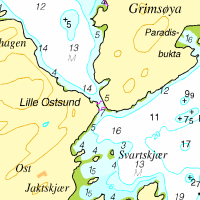
Chart thumb

Lille Ostsundet

Latitude: 59° 52.305 N
Longitude: 10° 35.21 E

Click chart to view larger scope, or here for an even larger scope in a separate window.


Chart data ©Kartverket.

We can party too..

Surrounded by party boats, we decided to have our own party.

The ambiance has changed a bit since the last time we where here, when the anchorage was filled with pleasure crafts and the sound of many small polite dinner parties, to now with as many as eight party boats simultaneous, stuffed with loud, obnoxious, company financed  drinking orgies. So, we decided we could party too.

Chart thumb

Ostøya

Latitude: 59° 52.636 N
Longitude: 10° 34.712 E

Click chart to view larger scope, or here for an even larger scope in a separate window.


Chart data ©Kartverket.

Birds and balloons

Hot Air balloon in the sky, eagerly watched by a group of feathered spectators. Can you spot them?

It is probably not as obvious in the wide angle shot above, but it looked like the bird colony were fascinated by the hot air balloon in the sky. Anyway, it was the highlight of this evening sailing.

Chart thumb

Galten

Latitude: 59° 53.546 N
Longitude: 10° 42.107 E

Click chart to view larger scope, or here for an even larger scope in a separate window.


Chart data ©Kartverket.

Perfectly shaped

Gennaker almost nicely shaped
A Gennaker, not so perfectly shaped. Well, not in this picture anyway. But that is just because the helmsman fiddled with the camera, in stead of steering the correct angle to the wind

It took 3 tries to get it right. On this day, in 3-4 m/s wind, the gennaker popped into a perfect shape at 60 degrees apparent wind angle. Best of all, we managed to roll it up tight at the end of the day, without the top blowing out as has happened at earlier tries.

Chart thumb

Ildjernet

Latitude: 59° 51.017 N
Longitude: 10° 37.794 E

Click chart to view larger scope, or here for an even larger scope in a separate window.


Chart data ©Kartverket.